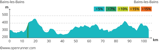
This tour will take you over a distance of 104 kilometres with an accumulated elevation gain of 1270 metres. It winds over hilly roads through the Vôge, an area reputed for its vast forests and numerous rivers. For part of the way it follows the route of the ‘Ronde des Vosges’, a regional cyclist race which has been held here for over 40 years.
Leave Bains-les-Bains heading south along the D434. You can warm up on this downhill stretch of about 10 kilometres which borders the Canal de l’Est (the Canal of the East) and the Coney river. Beware of the cobbled streets when you reach Fontenoy-le-Château and secure your water bottles. After the port, there is a slight climb up to the Grand Bois and then to Gruey-les-Surance, the highest point on the route. You will have time to recover as you wind your way through the enchanting valley of the Ourche to Droiteval Abbey. Here the going gets harder with a 14% climb up to Claudon. Continue for roughly 20 kilometres through Monthureux-sur-Saone until you come to Morizécourt. Head for Provenchères-les-Darney along the D15, which winds along the old Roman road. Cycle round the north of Darney, past Lichecourt castle and over the Saône at Bonvillet. A deceptively flat 10-kilometre stretch of road climbs up to Vioménil, which is the source of the Saône. Cycle along the banks of a stream called Les Cailloux and then down a narrow winding backroad to La Forge de Thunimont. Here you come to the Grande Fosse hill which is the last difficulty on this tour.