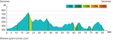
This woodland tour to the north of Saint-Dié-des-Vosges will take you round the Ormont mountain and to the highest point in the Donon massif. It is a demanding route over a distance of 85 kilometres with an elevation gain of 1470 metres. With its gentle uphill slopes and short technical descents, this tour has something for all types of cyclists.
Leave from the Tourism Office of Senones. Take the direction of Moussey along the valley of the Rabodeau river, a good stretch for warming up. The road climbs gradually over a distance of 18 kilometres with a 7% gradient in three places and a flat stretch to finish. Whatever the season, you will admire the colours of the trees in the forests as you cycle through between Saulcy and Ban-de-Sapt. The worst is over. A gentle hilly road takes you over the Hermanpaire pass to La-Petite-Fosse. Take it easy over the next fifteen kilometres until you reach the Paradis Forest. The ascent up to Robache is followed by a steep descent to the foot of the Raids de Robache pass. Proceed to Saint-Jean-d’Ormont and then along the Hure river till you reach Hurbache. Climb the next hill and then proceed to Moyenmoutier from the top along a small winding road which literally plunges you headlong into the forest below. The ascent of what might be described as a pass brings you to a place called Le Palon — the 7% gradients in places are the last difficulty on this tour. Finally, return to Senones.