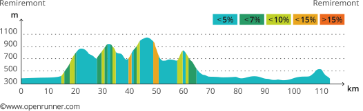
This 114-kilometre tour with a 2000-metre elevation gain is tailor-made for sporting cyclists.
Starting at Archettes you cross the Moselle and follow signs to Arches, along a shady rolling road up to Remiremont. Be careful when you approach the interchange with the RN 57 trunk road, as the traffic here is heavier.
When you reach Remiremont ride along he railway line and then the lake. Follow the left bank in the Valley of the Moselotte as far as Vagney. This marks the beginning of the mountaneous part of the route with four passes in quick succession; 28 kilometres of this challenging stretch follows the 2014 route of the Tour de France. After La Mauselaine, ride through the centre of Gérardmer along the forest road called the Dix-Sept Kilomètres (*). After a good downhill stretch, take it easy and ride round the lake before returning to Vagney over the last pass. Ride back to Archettes along the right bank of the Moselle.
Variante : Purists may wish to take the Tour de France route for professional cyclists. After leaving La Bresse, you come to the pass called the Grosse Pierre. Turn left along the Chemin de la Roche for three kilometres (a 7.5% climb on average with a 16% gradient on one stretch).
(*) Private road managed by the French Forestry Commission use of which is normally restricted to forestry vehicles.